Pune
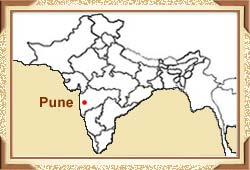
geographical location is such that the city lies between 18 degree 32' N
latitude and 73 degree 51' E longitude. Situated near the western margin
of the Deccan plateau, it stands bordered by hills on the east as well
as the south. Pune is approximately 50 km from the Western Ghats and 100
km to the east of the Konkan i.e. the west coast. At an altitude of
approximately 560 m above sea level, it falls on the leeward side of the
Sahyadri Mountains. Read on to know more about the location of Puna,
India.
The city lies near the convergence point of rivers Mula and Mutha. The
northwestern outskirts of Pune's urban area serves as the crossway for
two other rivers, namely Pavana and Indrayani. The southern boundary of
the urban area is formed by the Simhagad-Katraj-Dive ghat range. As per
the location pf Pune, the Vetal hill, situated at an altitude of 800 m,
forms the highest point in the city. At the same time, the highest point
of the urban area is represented by Simhagad fort, located at a height
of 1400 m.


 Pune
geographical location is such that the city lies between 18 degree 32' N
latitude and 73 degree 51' E longitude. Situated near the western margin
of the Deccan plateau, it stands bordered by hills on the east as well
as the south. Pune is approximately 50 km from the Western Ghats and 100
km to the east of the Konkan i.e. the west coast. At an altitude of
approximately 560 m above sea level, it falls on the leeward side of the
Sahyadri Mountains. Read on to know more about the location of Puna,
India.